Lewis and Clark Cycling Trek

Wednesday, June 29, 2005

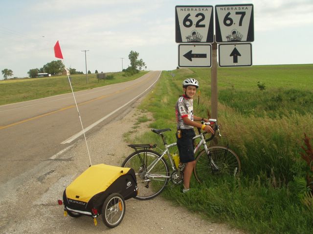
Snake Creek Recreation Area to Chaimberlain, SD- Day 16- 45.70 mi.

SpokeWrench said today... "In Indiana, you would call today a windstorm, but in South Dakota, they just call it Wednesday."

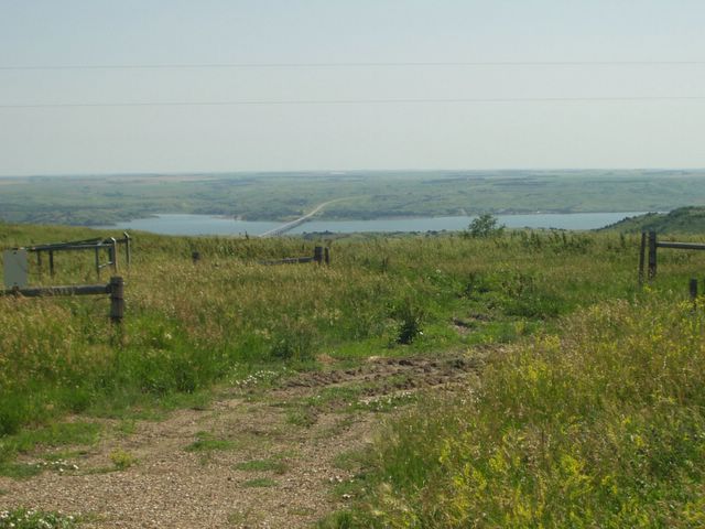
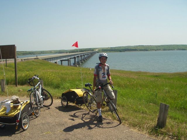
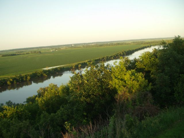
We got another late start today. We wanted to start early because high winds were predicted for this afternoon. When my cell phone alarm rang at 5:15, simultaneously it began to rain along with thunder and lightning...not so conducive to cooking breakfast and packing our things, so we rolled over in our sleeping bags and slept for another hour and a half. By then the rain had stopped, so we got up, had breakfast, packed up, and left by 8:45. (No matter how hard we try, it still takes two hours to get out of a campsite.) At 10:30, the National Weather Service came on our two-way radios and issued a high wind advisory from 3:00 p.m. to midnight today. They predicted west winds to exceed 35-40 mph with gusts in excess of 50 miles per hour when the front passes through the area. Our route today is mostly northerly but I was bothered because the last 8 miles or so we would be heading due west. That would put us in the right time frame for those 50 mph winds to be directly in our faces. We tried very hard to beat the cold front to our destination of Chamberlain, but by 11:30 there was already 20-25 mph winds from the northwest. This made a quartering headwind that slowed us to 9-10 mph. We were not making very good time. On top of that, there were no restaurants in the entire 45 mile route, so it was necessary for me to cook a package of ramen, literally on the roadside. Predictably, we came to that last 8 miles at just about 2:30...and for once the weather service was on the money. Right on queue, the sky became partly cloudy and the wind picked up from 20 mph to what I would estimate at 30-40 mph with higher gusts, straight in our faces. That last 8 miles, took us almost 2 hours to ride. On the flat stretches we were lucky to make 5 mph (not much faster than walking) and even that took all the strength we could muster. The gusts would almost completely stall us. We just put our bikes in the lowest "granny" gear we had and pushed forward. When we finally did arrive at Chamberlain, I couldn't see how our tent could hold up under this kind of wind, so we opted for a motel, hoping the winds would calm down by tomorrow. So here we are at the AmericInn working on the blog. At dusk tonight the wind did start to calm down. Hopefully it will allow us to continue tomorrow. I have read in the Lewis and Clark journals, that they also experienced these kinds of winds and in their bulky boats, and it made it nearly impossible for them to continue until more favorable winds came along.
Seventh Grade Question:
The name of the town we are staying in tonight reminds Spokewrench of a former famous NBA player. What was his full name and what was one of his major accomplishments?

-ClarkWheel


1000 feet above the Missouri River bridge near Snake Creek Recreation Area


Close-up of the bridge over the Missouri River and Lake Francis Case


The snake at Snake Creek Recreation Area

Burke, SD to Snake Creek Recreation Area- Day 15- 25.81 mi.

We traveled a more modest 25 miles today. As we left Burke this morning, a man stopped and told us that severe weather was expected this afternoon and evening and that he recommended we find lodging early. We had intended on trying a 68 mile day. The only other option was the 25 mile ride to Snake Creek Recreation Area. We had a nice, relaxing ride. We have been traveling over 2000 feet and we knew that Snake Creek was going to be about 1000 feet lower. We came around a broad curve in the road and could look down almost a thousand feet to the bridge crossing the Missouri River and our campground on the other side. After an exhilarating 3 or 4 mile downhill, we arrived at Snake Creek and immediately knew we had made the right decision. It was a beautiful campground. We set up camp and spent the afternoon at the beach, playing croquet, and just enjoying the atmosphere. The severe weather that was predicted never panned out, thank goodness! Snake Creek did live up to its name, because as we were returning from the marina where we had supper, I spotted a 3 or 4 foot white-colored snake with blackish diamonds in the road. I stopped, took some pictures, and tried to shoo it off the road so it wouldn’t get killed, but it would have no part of that. It coiled and started hissing, mouth wide open. I tried to get another picture of that, but it turned out rather blurry. It finally crawled off when I walked away. I think the snake was a bull snake, harmless, but fairly aggressive. I have read about this snake but have never been lucky enough to see one until now.
Seventh Grade Question:
Speaking of animals…What is the state animal of South Dakota?
-ClarkWheel


Downstream from the Fort Randall Dam


A portion of the Fort Randall Dam

Pickstown, SD to Burke, SD- Day 14- 49.51 mi.

Major uphill right from the get-go this morning. We left the hotel and headed exactly in the wrong direction. It took us only about a half a mile to figure that one out, so we turned around and went the right direction. This took us across the Fort Randall Dam. The dam is over the Missouri River and it forms another large reservoir. The road across the dam is about a mile long. We could see, below the dam, the tamed Missouri River and the surrounding countryside very clearly since we were up fairly high. Unfortunately we were not as high as the road would take us, because we had a major climb ahead. I would estimate the climb over the bluff was about a mile to a mile and a half long. What a way to wake up my legs. Good morning, legs!! We climbed gradually all day today. The terrain was rolling; it seemed the uphill was always longer than the downhill. Of course, it always seems that way, but today it actually was. We started from Pickstown at an elevation of about 1500 ft. and ended up at an elevation of 2210 ft. In addition we had a quartering headwind all day long. We accomplished our 49.51 miles by about 4:00 p.m. and were fairly tired. Although the route was busier, the landscape remained desolate but beautiful. We are watching for antelope and prairie dogs. They say there are some in this area. I did see my first long-eared jackrabbit, but in a two-dimensional sort of way. It had been flattened on the road.
I mentioned earlier that we crossed over the Fort Randall Dam and I will post a picture of the landscape downstream from it. This dam was built not only to tame the river but also to generate power. Which brings us to….
The Seventh Grade Question of the day:
What is the power called that is produced by water rushing through generators built into a dam?
-ClarkWheel

Sunday, June 26, 2005

Lewis and Clark Recreation Area (Springfield) to Pickstown, SD- Day 13- 48.73 mi.

Wow…what a day…the temperature soared into the 90s, with heat indexes into the 100s. The major energy-taker today was the wind. In the morning, it was mainly a tailwind, 10-20 mph. As we came into Pickstown, the wind became a cross-wind and strengthened. It was about 40 mph! I was blown off the road into some loose gravel 7 times. Once, it brought my bike and I down to the road. I was okay, though. Through all this, we were going uphill. Our speed was only 5-6 mph. We didn't get an early start and that forced us to bike in the heat and high winds. We certainly paid the consequences for that extra hour of sleep this morning. The route we biked today was one of the most difficult we have had so far. It was desolate but beautiful. From the time we left Springfield until we arrived at Pickstown, almost 50 miles away, we did not see one convenience store, gas station, grocery store, or restaurant and less than 15 cars had passed us. We were forced to cook a modest noon meal along the roadside in the hot sun. We also nearly ran out of water today. We both carry 3 waterbottles, and, luckily, ClarkWheel had filled a Nalgene quart bottle as well. At the top of several hills, we could look around and see nothing but more rolling prairies….no towns, farms, or even buildings. We found only one shade tree at a Native American boarding school in Marty, SD. This brings us to our question for the day.

Seventh Grade Question: This Native American boarding school for boys and girls for the Yanton Sioux Tribe has a program much like our D.A.R.E. program. This program is targeting tobacco use. It is called T.A.T.U. Just like D.A.R.E., the letters are an acronym. What are the words for this acronym, T.A.T.U.

SpokeWrench

Lewis and Clark State Recreation Area (Yankton, SD) to Lewis and Clark State Recreation Area (Springfield, SD)- Day 12- 29.84 mi.

We told you that the reservoir was big! We biked about 30 miles and we were still on the same reservoir and part of the same state park system. Today was much cooler. It was overcast and only reached about 80 degrees. The wind was much lighter and it was a tailwind. We did leave the flat lands and are back in the hills of South Dakota, but those hills didn't seem so bad with cool weather and tailwind. We noticed much more wildlife sign than anytime before. In some of the wetlands along the Missouri River, we saw a large beaver lodge. We often heard ring-necked pheasant along the roadside and saw one scamper across the road ahead of us. Killdeer followed us and scolded us if we passed too close to one of their nests. When we arrived at our campground, we saw a wild turkey hen leading a small flock of chicks around in a bean field behind our tent. This campground had recently had a flashflood and a great deal of wood had been washed out of the woods behind. This allowed us a chance to gather some wood and have our first campfire of the trip. After dark, the plaintive call of the whip-poor-will could be heard throughout the night. All-in-all it was a pleasant day and evening.

Seventh Grade Question: For lunch on most days, we stop at a restaurant for a burger. These burgers are usually about 1/3 of a pound. On the Lewis and Clark Expedition, how much meat did each of the men on the expedition eat each day on average? (Hint: It is a lot more than we eat a day.)
ClarkWheel

Vermillion, SD to Lewis and Clark State Recreation Area in Yankton, SD- Day 10/11- 50.81/0 mi.

Key words: Hot and Windy
The temperature today soared into the upper 90's before we arrived at our destination and the wind was from 25-35 miles per hour. It was a crosswind, not a tailwind. It was very difficult to keep the bicycles on the road at times. The terrain was very flat. The ride itself was uneventful if you call riding in the heat and wind uneventful. We stopped at Ma and Pa's Convenience Store for delicious burgers. The owners were very helpful, even calling ahead for us to get campground reservations for the night. We got the last electric campsite available. This was a huge campground with nearly 400 sites and lots of things to do. After arriving, we spent an hour or so swimming in the reservoir behind the dam on the Missouri River. It was so windy that there were 2-3 foot waves on the gigantic reservoir. We decided to take a rest day and spend a second day here. Well, we got plenty of rest on Day 11 because at about 9:00 a.m. it started to rain and rained until almost 4:00. We had to change campsites in the rain because our first site was reserved for the second night. It is not fun changing campsites in the rain. We spent quite a bit of time in the tent that day playing Lewis and Clark gin rummy, updating our written logs, and reading some of the materials about Lewis and Clark. We did take one rainy ride about 6 miles to a camping store to get some Coleman fuel for the stove. After it stopped raining, we went down to another beach to swim and skip stones before retiring for the evening.

Seventh Grade Question: This is a math question. Feel free to call Mr. Mohler for help (I didn’t clear this with him, though). Part of the day going to Yankton we traveled a fairly busy highway. Sometimes to prevent boredom, we count cars that pass us, but we often forget how many cars. To prevent this we have devised a method for counting cars on our fingers and let those fingers keep track for us. Now if we used our ordinary "Base 10" we could only count to 10 and then have to start over. But there is another way. By taking advantage of other bases, we can keep track of far more on our fingers. Here is the question; what is the most or highest number of cars we can keep track of on our 10 fingers and what base would you use to do that. Good Luck!! (If this question is not understandable, let us know and we will try to clarify it.)

ClarkWheel

Sioux City, IA to Vermillion, SD- Day 9-45.51 mi.

Key word: Hot!

We started later today because we wanted to take advantage of a bike shop very near the hotel. Our bikes needed some adjustments, I needed more tire tubes especially for the trailers, and I wanted to replace Tai's broken waterbottle cage. Albrecht's Bike shop took care of all those things and we were on our way by about 9:30. Albrecht's shop suggested an alternate route that took advantage of some great bicycle trails. We just got on the trail when we arrived at the Lewis and Clark Interpretive Center. It was a great museum. We didn't take the time to listen to the 1 hour tour but did our own little tour. They even had wax representations of Lewis, Clark, and Seaman. Lewis and Clark talked, moved, rolled their eyes, and made hand gestures. Seaman barked, but we couldn't quite interpret that. It was rather eerie. We left at about 11:00 and it had become quite hot, so we sweated our way to Vermillion. In the process we crossed the Little Sioux River which put us in South Dakota. Vermillion had a very nice campground that was free, but no showers. We had a restful night there.
Seventh Grade Question: The Native Americans in the Vermillion area spoke of a very sacred place. All Native Americans respected this spot and left it alone. They believed that very tiny people with big heads lived on this spot and could kill intruders with very powerful bows and arrows. Lewis and Clark climbed to this spot when they found it. What is the name of this spot? P.S. They didn't find the big-headed little people.

ClarkWheel

Tuesday, June 21, 2005

Lewis and Clark State Park to Sioux City, IA- Day 8- 44.67 mi.

Our tent has been intiated with wind and rain! After retiring for the evening, high winds in the 30-40 mph range started up followed by thunderstorms the remainder of the night. The tent (and its occupants) held up well, but didn't get a very good night's sleep. We awoke at 8:00 a.m.snug and dry. We were on the road by 9:15. The terrain remains very flat with winds from the east today. Not exactly a tailwind but not a headwind either, thank goodness. We are headed today for one of the last big cities of the trip, Sioux City, IA. We decided at Salix, IA, where we stopped for lunch to get a motel room so we could upload the last 3 days and have a swim in the pool. We also have some minor things we need to take care of at a bicycle shop in Sioux City. I must say that Sioux City is one of the most confusing cities in which to bike. On the outskirts, we called the Best Western where we had a reservation to get directions downtown. It was so complicated, the motel "air traffic controller" as I called her, had to research the best way and call us back. We finally made it and, while doing the laundry, we soaked in the Best Western's fine pool. Ahhhhhhhh!!
Seventh graders, here is your question for the day: On Lewis and Clark's trip to the Pacific, only one man died along the way and that was in the present day Sioux City, IA. What was this man's name and what do historians think he actually died from?

P.S. Spokewrench would write something, but he is too busy watching the NBA finals. Go Pistons!!

-Clarkwheel


Picture #2 for Seventh Grade Question


Picture #1 for Seventh Grade Question

Missouri Valley, IA to Lewis and Clark State Park- Day 7- 46.07 mi.

We left our blog address with another gentleman today. We were biking along after having left Missouri Valley earlier in the day, when a silver pickup followed us for a few hundred yards, then it passed us and pulled off to the side. As we approached, the truck took off again and further down the road it was parked in a driveway with a gentleman waving to us to stop. We stopped and talked to this fellow and he, too, was interested in our trip. Ken called himself a “touring wannabe” but because of too many responsibilities, he is unable to tour. He has ridden Registers Annual Great Bike Ride Across Iowa called the RAGBRAI for the past 16 years. It is 500+ mile ride from Iowa’s west border to the east border. Some 10,000 people ride this every year. I am totally impressed with 70 year-old Ken. Thanks for stopping and talking to us, Ken, and good luck on this year’s RAGBRAI.

We stopped tonight just south of Onawa, IA at, appropriately, Lewis and Clark State Park. It was a beautiful campsite within 10 feet of Blue Lake. This state park is unique because it has the exact replicas of the two kinds of boats that Lewis and Clark used for their transportation from St. Louis. That brings us to the Seventh Grade Question for the day: What were the names for those two kinds of boats that were used by the Corp of Discovery? They can be seen here in picture #1 and #2.

Council Bluffs, IA to Missouri Valley, IA- Day 6- 26.48 mi.

We did a little sightseeing today…but it is difficult and expensive. It is difficult because in a fairly large city, a bicycle just can’t get places without riding on expressways. We don’t know the way around on the back streets. It is expensive because the other choice is a taxi. This is what we did, but it cost $13.00 one way to get to the Western Historic Trails Center. We enjoyed our time at the Center even though it cost $26.00 just to get there and back. After returning from the Western Historic Trails Center, we checked out of the Heartland Inn at 12:00 and headed for Missouri Valley, IA. The big story about the remainder of the day was the people we met along the way today. We stopped at Henry’s Diner in the small town of Cresent, IA for a burger. While we were waiting for our lunch, a couple stopped by our table to ask about our trip. They seemed very interested and we talked for sometime. We said our good-byes and then they turned back and Dick handed me a ten-dollar bill and said, “There’s a great ice cream place in Missouri Valley. Go enjoy some on us.” We did just that when we arrived later that day and Dick was right…it was great ice cream! Thanks, Dick. We continued on and soon met another biker going the opposite direction. He had started 3 weeks ago at Williston, ND where we hope to be in a few weeks. This gentleman is moving a lot faster than we are, so I don’t think we will be there in 3 weeks but that remains to be seen. We camped at a city park in Missouri Valley. There weren’t any showers but it was a very clean park and we enjoyed our stay.

Seventh Grade Question: Today we visited the Western Historic Trails Center. Besides the Lewis and Clark Trail, what 2 other trails started in the Missouri River area and continued to the Pacific Ocean?

Saturday, June 18, 2005


A view of a bridge on the Steamboat Trace, a converted railroad bed.

Nebraska City, NE to Council Bluff, IA- Day 5- 52.56 mi.

I wonder if Lewis and Clark ever had a problem like this? I carry only one pen and one mechanical pencil with me. I realized yesterday that I had lost my good pen. I pulled out my mechanical pencil and, you guessed it, I am out of lead. Finding a convenience store to buy a new pen and/or pencil lead became a priority. Today, it was almost as difficult to find a pen or lead as it would have been for Lewis and Clark. We biked 50 miles today without seeing one convenience store, restaurant, or even a grocery store. When we finally arrived at Council Bluffs, IA, I was too tired to even care about a pen or pencil, so I am still without either.

Except for Nebraska City, where we camped, we were fortunate today to have flat roads and a nice tailwind. Almost all of our miles were completed on a two-lane road that paralleled Interstate 29. It was a flat and very quiet—almost no vehicular traffic. That was the good part. The bad part was that, as I mentioned above, there were no services…no convenience stores, restaurants, or grocery stores. This made it necessary for us to stop at mid-day and cook our lunch. Luckily?? I am carrying about 20 lbs of food, a stove, and cookware, so I could set up shop and cook a meal fairly quickly.

Towards the end of the day, we again had the pleasure of riding on the Wabash Trace, another railroad converted to a hiking/biking trail. This was very well-maintained with rest benches about every ½ mile. We will be back on this trail again tomorrow when we leave Council Bluffs. We are at a motel in Council Bluffs tonight so we can upload this journal, have a great shower, and visit the Historic Western Trails Museum in this city. We plan a short ride tomorrow starting around noon after visiting the museum. See you at the next connection.

It’s time for the Seventh Grade Question of the Day! Today we crossed the Missouri River into Iowa. What states have a portion of their border defined by the Missouri River?

-ClarkWrench


Missouri River at dusk from 4-state look-out point at White Cloud, Kansas


On the way to Nebraska City, NE

Falls City, NE to Nebraska City, NE -Day 4- 55.38 mi.

Today we biked from Falls City, NE to Nebraska City. For the most part, it was a flat ride. When we first left Falls City, it was quite hilly, but flattened out after the town of Nemaha, where we ate lunch. Soon after Nemaha, we had the pleasure of riding on the Steamboat Trace, a hard-packed limestone trail, similar to the KATY Trail in Missouri. Steamboat Trace started in Brownville and went almost to Nebraska City, a distance of 22 miles. This was nice because it was flat, had no cars, and there was a lot of wildlife. We had been on the trace only 10 minutes when 2 tiny fawns and a doe trotted ahead of us on the trail. Overall it was a fine ride. The only problem we had was that near the end of the trail, ClarkWheel had a flat tire. We stopped and fixed that, and moved on. We had the choice of stopping in Peru, about midway on the trail, but learned there were no showers and so we decided to go on to Nebraska City. When we reached the end of Steamboat Trace, we had to ride for 1.5 miles on very loose gravel. We probably would have been better off walking the bikes instead on trying to ride them. Both of us almost went down while riding. On the final 6 or 8 miles, we encountered many large hills that were long and fairly steep. These were some of the most challenging hills we have had. ClarkWheel's chain slipped off climbing one of those hills and my bottom waterbottle cage broke off causing me to run over it and the waterbottle. It could have been a bad scene, but I managed to keep control of the bicycle. We had a hard time reaching the campground, but when we got there, we were happy. It had been a long, hard ride. Our question for the Seventh Graders pertains to Steamboat Trace: The Steamboat Trace trail is funded and maintained by a large, nationwide organization that uses abandoned railways to make bicycle and hiking paths. The KATY and Steamboat Trace are two trails this organization made and maintains. What is the name of the organization? (Mr. G is a member of this group.)

-SpokeWrench

Thursday, June 16, 2005

White Cloud, KS to Falls City, NE--Day 3- 23.68 mi.

We had a short day today for several reasons. First in order to be able to find lodging at reasonable riding, distances, we either had to do one rather short day or one very long one. We chose to do a short day. We have laundry to do, we have tent seal to apply to our tent, we need to get these last three journals uploaded, and we both desperately need a shower. We have biked about 23 miles so far and are staying at a small motel in Falls City, NE. It doesn't have internet access, so we biked back downtown to the local library where internet access is available. This is a great little library. It not only has high-speed internet service for free but they even let us plug our laptop into their system so we could upload some pictures. The trip to Falls City, NE was a breeze, literally. The wind switched during the night and we were blessed with a tailwind, plus the road to Falls City was completely flat. It just curved back and forth around the bluffs. The Missouri River was often visible on our right. It was just a very pleasant ride. Today we crossed the Kansas/Nebraska border. Seeing the last Kansas road sign brings us to the Seventh Grade Question for day 3: The road signs in Kansas have, instead of an outline of the state of Kansas, a picture of their state flower. What is the state flower of Kansas?

Until our next connection location....
-Clarkwheel and Spokewrench


A monument at White Cloud, Kansas.


The mallard duck at Lewis and Clark State Park


The traffic jam (in front of us)


The traffic jam (behind us)


This is what our car looked like on the trip to Kansas City

Lewis and Clark State Park, KS to White Cloud, KS--Day 2- 43.93 mi.

This was the second difficult day in a row. The "double h's" got us again....hills and headwinds. The first part of the trip was particularly difficult with very looooong, steep hills and then headwinds the entire way. We were determined to get to a campground at White Cloud, KS that we found on our maps. We also learned a lesson, always eat plenty along the way. We ran out of "body fuel" with about 10 miles to go out of Troy, KS. I found some snacks in my bag and utilizing that, we pushed on to Troy where we consumed 2 big Kansas beefburgers. From there we traveled on to White Cloud, still with a headwind but it was FLAT...what a blessing! Upon arriving at White Cloud, we were initially disappointed to find the campground looked a lot like a parking lot. There were no showers, no hot water, pit toilets, and no other campers. On the brighter side, our tent was within spitting distance (literally) of the Missouri River and it was a beautiful view! We hadn't been there too long when a gentleman approached us and introduced himself as Wolf River Bob. This bewhiskered local historian gave us the lowdown on the local history and then he produced a book of names and comments of many other visitors to White Cloud. We signed in just as all the others had done. He then invited us to go with him in his van to see some of the sites of this little town of 216 residents. He knew every house and knew the history of each. He took us to a property he owned on a large hill overlooking the Missouri River and then took us up to the peak of another large hill. At the top of this, we found a lookout...which brings us to today's Seventh Grade Question: From the lookout in White Cloud we could see 4 different states. Use your knowledge of our location to identify the 4 states we could see. Thanks to Wolf River Bob and his great tour!
-Clarkwheel

Platte City, MO to Lewis and Clark State Park--Day 1- 20.87 mi.

Today we biked from our hotel in Platte City to Lewis and Clark State Park. We left at about 10:00 today. The slow start was because we had to take the rental car back to Avis. When we finally did get started, our cyclocomputers were not working. We think it was because the front wheel was taken off and put back on, and the position was a bit different. The hills of Missouri finally came back to haunt us. There were many hills right at the start of our trip. They were long and steep. We had trouble getting up them and had to take water breaks midway through. I was surprised as to how much harder it is to pull a trailer uphill. I was not expecting it to be such a hard task. Also, we faced a strong 20+ mph head wind. This also slowed us down. Between the weight, the wind, and the hills, we could not go more than 8 mph on flat sections. Hills averaged 6-7 mph., and downhills only averaged 13-16. I made this comment along the trail: "In Indiana, a cyclist hopes for downhills. In Missouri, a cyclist hopes for flat areas, but downhills are okay too."

-SpokeWrench

I agree with SpokeWrench. It was a difficult day...between the hills, the wind, and not being accustomed to pulling the heavy trailers, we didn't gain much mileage. By 2:30 in the afternoon and 20 miles, we were shot. We did meet up with a very kind electrical employee who gave us ice-cold water and Gatorade along the roadside. It certainly raised my spirits. We now relax in a cool breeze which doesn't seem nearly as daunting as before. We are sharing our campsite with a mallard duck sitting on a clutch of eggs under the same tree as our tent. She doesn't seem to mind at all. We also found time to make another question for the Seventh Graders: We are currently 5-10 miles from the most haunted town in the U.S., according to the Travel channel. What is the name the name of the town and the state in which it resides? Remember, do not post answers on the blog!

-ClarkWheel

Monday, June 13, 2005

On The Way to Kansas City

I write this post sitting in a Ford Explorer, rented from AVIS. We picked up the car at about 8:00 a.m. and got everything packed by 9:00, and were on the road at 9:26. We expect the ride to be about 12 hours. We should arrive in Kansas City about 10:00 p.m. All of our gear fit in the back of the Explorer, with the third and second row seats folded down. The bikes are placed upside down, with the front wheel off. The trailers went in between the bikes, with the wheels and hitches taken off. We strapped our mascot, Scout, to one of the wheels. He now has a good view out the back window. We are both surprised as to how well the bikes and trailers fit in. Last year, we had only one trailer but were more packed than this year. We drove a Pontiac Aztec last year. ClarkWheel and I were both wondering if we would be able to fit everything in with this SUV. And, we were surprised when the bikes and trailers went in so simply. Both of us called it "too easy."
At about 1:30 we stopped at a travel plaza for lunch. We were back on the road by 1:45. Shortly after entering Missouri, we encountered heavy rain and lightning. We were forced to pull over until the conditions improved. The sky seemed to be a greenish blue, the type of sky tornadoes come from. We didn't see any, though. At about 5:30, we encountered a massive traffic jam. Traffic was stopped as far as we could see. Many people were out of their cars (including us) and were discussing the situation. It turned out to be an overturned semi ahead of us. The storm was thought to be the cause of it. We didn't start moving until about 6:30.

ClarkWheel and I finally pulled into the hotel at 10:07, after about 12 hours. The entire trip was about 600 miles.

Sixth graders, we now give the first question of the trip: Our destination today is Kansas City. When Lewis and Clark came to the present-day site of Kansas City, it was the confluence of the Missouri and another major river. What is the other river? Write down the date of this post and the answer to the question on a Word document. Remember, do NOT post answers on this blog. Any such comments will be immediately deleted. If you post the answer on the blog, everyone will know the answer, therefore lessening your chance of winning the prize.

Saturday, June 11, 2005


These are our bikes. Tai's is in front, Pardee's in back.

Friday, June 10, 2005

2 Days Remaining

Perhaps there are some of you interested in our gear for the journey. First, our transportation will be Giant OCR touring bicycles. Tai’s is a 2004 ½ model and mine is a mere 2004. (He often reminds me of this.) Besides the Giants, we also looked at the Trek 720 Touring bike and the Surly Long Haul Trucker. I love that name, Surly Long Haul Trucker... I was tempted to buy that bike because of the name...but we settled on the Giants for several reasons. The aluminum-bodied Giants provide a very smooth and stable ride but are still very light. The bike shop provided a Giant OCR for us to try and we were both impressed by the smooth ride. Giant is the only one of the three that comes standard with disc brakes. This was the final point that sold us on these bikes. We feel that disc brakes provide us with more powerful stopping power, needed since we both will be pulling trailers. Disc brakes are nearly impervious to rain, providing reliable stopping power in all kinds of weather conditions. We purchased the bikes in March and, added together, we have already logged nearly 1000 miles biking back and forth to school. We are very happy with the bikes are looking forward to using them on the trail. Tomorrow I will post a picture of our bikes. In the meantime, check out www.giantbicycles.com if you have further interest.

-Clarkwheel

Tuesday, June 07, 2005

5 Days Remain

Only 5 days remain until the start of our journey. Everything seems to be ready. ClarkWheel and I have each taken training on basic repairs from Isaac at Trailhouse, the local bike shop. We covered such topics as adjusting disc brakes, changing brake pads, emergency chain repair, bike lubrication, spoke replacement, trueing a rim, and cable maintenence. To our repair kit we have added a bike Multi-Tool, a master chain link, Tri-Flow bike lubricant, and a spare derailluer hanger.

Here are our email addresses if you would like to contact us personally.

ClarkWheel (Mr. G) pardee216@yahoo.com

SpokeWrench (Tai) tg6392@gmail.com

If you would like to be notified when this page changes, click here. Type you email and click Watch it!

-
SpokeWrench